Showing posts with label hurricane. Show all posts

Thursday, June 4, 2009

Models Sniffing Tropical Development


Everyday, whether I am making a forecast or not, I check the long range models to see the overall patterns in the atmosphere. The past few days have been interesting as far as the long range GFS is
concerned.

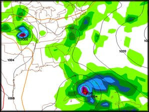
The model is trying to forecast a tropical cyclone forming south of Cuba and then intensifying and moving that system N then NNE over Cuba and right up through the heart of the Bahamas. All of this in the time frame of Tuesday through Friday of next week. The image here is on 8 a.m. Thursday June 11, next week. If this develops and takes the course it has been suggesting, two big IF's, we would be spared the worst of the storm, but Miami and the rest of southeast Florida would really need to pay attention. The GFS has a tendency to pop these systems this time of year and this far out in time, but it can't be written off as a fluke. We typically look for development this time of year in the western Caribbean and the Gulf of Mexico and those storms typically take a NW-N-NE track as well.
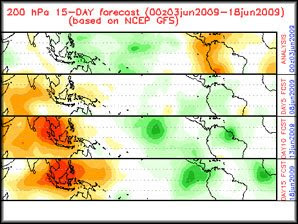

Also, an upward motion pulse is headed towards the western Caribbean around that time. This is a look at the potential for upward velocities, meaning broad areas of rising air. These areas traverse the intertropical convergence zone and vary from rising air to sinking air. The best chance to get storms to develop occurs when there is a large area of rising air. In this image, the green represents the rising air while the orange shows the sinking air.

So, yeah it is a little ways out, but I will be watching this closely. This is a good time to make sure your hurricane kit is ready to go, just in case this develops. Stay tuned!

Tuesday, June 2, 2009


The 2009 Atlantic hurricane season officially begins today, so I figured I would talk a little about the storm naming process.

The World Meteorological Organization maintains and updates six lists of tropical cyclone names for the Atlantic basin, one list per year with each list repeated once every six years. Before 1953 latitude and longitude numbers were used to refer to storms, however that proved to be a little confusing. That's why in 1953 they started using names to refer to the storms. The lists initially contained only female names, but since 1979 male names were added and now each list alternates between male and female.

Devastating storms that cause major damage and/or are very costly have their names removed from the list for sensitivity reasons. Some of those storms include Andrew 1992, Katrina 2005 and even Ike from 2008. The WMO then replaces the name with a new one.

This year's forecast is for an near average storm season which would mean around 10 named storms.

Here is this years list.

2009

Ana
Bill
Claudette
Danny
Erika
Fred
Grace
Henri
Ida
Joaquin
Kate
Larry
Mindy
Nicholas
Odette
Peter
Rose
Sam
Teresa
Victor
Wanda


Forecasters at Colorado State University issued an update on their 2009 Atlantic hurricane season forecast today and are now calling for average or just below average hurricane activity in the Atlantic basin.
Citing a neutral ENSO now with the possibility of a weak El Nino developing later this summer and cooler than average Atlantic water temperatures, Dr. Philip J. Klotzback and William M. Gray are now calling for 11 names storms and 5 hurricanes with 2 of those becoming major hurricanes. An average hurricane season consists of 10 named storms, 6 hurricanes with 3 becoming a major hurricane, category 3 or higher.
They are also calling for a reduced risk for a landfalling storm on the Unites States coast. The average over the last century is 52% while this year there is only a 48% chance for a U.S. coastline strike. According to their forecast, Florida and the eastern U.S. seaboard have a 32% chance for a landfalling storm this year.