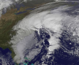
 Much of the east coast from New Hampshire to Georgia have felt the effects of Ida's remnants with NJ, DE, VA and NC taking the brunt of the storm.
At one point yesterday, the minimum central pressure of the nor'easter was lower 15 miles east of Cape Hatteras than it was at landfall in Alabama as a tropical storm. Ida made landfall with a pressure of 999mb, while a measurement of 992mb was recorded off the Carolina coast Thursday, Nov 11, 2009. It was stronger along the east coast versus the Gulf coast!
Although winds have been strong, it is more the duration of those winds and their affect on the ocean that has caused the most damage. Nags Head, NC has sustained quite a bit of oceanfront damage to homes and parts of HWY 12.
Winds have been averaging in the 30's and 40's with wind gusts in the 50's and 60's with reports of hurricane force wind gusts (75 mph) in the tidewater area of Virgina. This area has experienced stronger storms before, but the damage is worse because the storm has been sitting here for 3 days now. That duration has allowed the storm to erode much of the protective dune system and the beach itself. As a result, as each successive high tide moves in, there is less in the way of natural protection for the property along the immediate coast. It's not like a hurricane or tropical storm that barrels through lasting a day or so. The longer this sits there, the easier it is for the sea to cause more damage.
Fortunately, the storm is now beginning to move back offshore toward the ESE and is loosing it's strength as it does so. This storm will go down in the history books as one of the worst as far as damage goes.
For a look at some raw video of damage in Nags Head, NC click here (courtesy of http://www.hurricanetrack.com/)

No comments:
Post a Comment