Friday, June 26, 2009

The "Cone of Silence". No, not Get Smart!

The "cone of silence" may refer to the sound proof area on the show Get Smart, but in weather terms, it refers to the area right above a radar that cannot been seen by the radar.

A typical Nataional Weather Service radar has a maximum tilt elevation of 19.5°. That means that as it scans around, the highest the radar can see is 19.5° above the earth's surface. Becasue of this, there is a large hole in the data created right over top of the radar. You can see rain all around it, but not above it.

They are tough to see unless you have rain over the radar, but when you do they are easy to spot. This image shows an example of a cone of silence. Notice the hole in the radar relfectivity data. The radar itself is located right in the middle of that hole.
Because of the cone of silence, radar sites are generally placed at sites away from a population center. This is so that you can get accurate data for the most densely populated areas. They are also placed outside of urban areas because tall buildings can block the radar, literally blocking the view of the radar.
Now , for those of you old enough to remember the "Get Smart" version of the cone of silence, the next time it comes up you'll have a little tidbit of information to add to the conversation ...and you know how often that comes up!

Sunday, June 14, 2009

Biscayne Bay, Memorial Day Weekend 2009


Just thought I would include a cool panoramic picture of downtown Miami taken from my father-in-laws 32' Sea Ray on Memorial Day 2009. Storms stayed south of Miami for most of the day allowing us to enjoy a great day on the boat. It was a great setup for meteorologists and weather enthusiasts alike as you could enjoy the boat and swimming on the sand bar, while watching a decent cell grow to the south and produce quite a bit of lightning.

We did catch a few sprinkles as we headed north for home in the evening, but we were able to out run it - outside of the no wake zones of course!

If you are ever over in that area, check out the stilt houses built just outside Biscayne Bay. You are not allowed to live there anymore, but that would be a dream place to live as long as no storms threaten.

Southeast Stickiness

Last week I visited upstate New York for a family wedding. I was greeted with a cool and dry airmass that I have to admit was a nice break from the heat and humidity here in west-central Florida. Don't get me wrong, I actually like the warm weather, but it was nice to get a cool shot of air...like that first cold front that comes through in the fall bringing the falls first shot of cool dry air.

The difference in airmasses reminded of the differences in regional weather. I know that many of the residents in the Tampa Bay area are from other places and/or have family spread out across the country, so I thought I would show you a few graphics that you can find on our new website http://www.forecastfirst.com/.

First off, lets take a look at the heat. As far as near or above average temperatures go, the heat as been mainly in the southeast U.S.


The dewpoints are a measure of the amount of moisture in the atmosphere. High dewpoints are what make the air feel moist and sticky, while low dewpoints make it feel dry. As you can see, the southeast and Florida have very high dewpoints. (not that this is out of the ordinary)

You can see more graphics like this on the new site. Take some time to look around as there is a lot to look at. In upcoming blogs, I will highlight specific areas on the site helping to point out just some of the great stuff on there. Enjoy the weather and enjoy the site!

Thursday, June 4, 2009

Models Sniffing Tropical Development


Everyday, whether I am making a forecast or not, I check the long range models to see the overall patterns in the atmosphere. The past few days have been interesting as far as the long range GFS is
concerned.

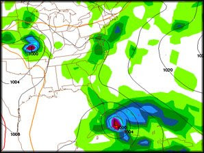
The model is trying to forecast a tropical cyclone forming south of Cuba and then intensifying and moving that system N then NNE over Cuba and right up through the heart of the Bahamas. All of this in the time frame of Tuesday through Friday of next week. The image here is on 8 a.m. Thursday June 11, next week. If this develops and takes the course it has been suggesting, two big IF's, we would be spared the worst of the storm, but Miami and the rest of southeast Florida would really need to pay attention. The GFS has a tendency to pop these systems this time of year and this far out in time, but it can't be written off as a fluke. We typically look for development this time of year in the western Caribbean and the Gulf of Mexico and those storms typically take a NW-N-NE track as well.


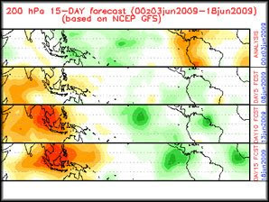
Also, an upward motion pulse is headed towards the western Caribbean around that time. This is a look at the potential for upward velocities, meaning broad areas of rising air. These areas traverse the intertropical convergence zone and vary from rising air to sinking air. The best chance to get storms to develop occurs when there is a large area of rising air. In this image, the green represents the rising air while the orange shows the sinking air.

So, yeah it is a little ways out, but I will be watching this closely. This is a good time to make sure your hurricane kit is ready to go, just in case this develops. Stay tuned!

Tuesday, June 2, 2009


Take a look at the latest satellite image from the Gulf of Mexico and let me know what you think. Water temperatures are just about 80F under that cloud mass and some models are trying to make a closed low out of this by late Wednesday and into Thursday before it moves onshore near the Florida panhandle and Alabama border. Does that sound familiar?

We just had a storm (no tropical classification) form over the Gulf a couple of weeks ago. That one too moved onshore near the same area and with some gusty winds and heavy rains. The NHC is not saying anything about it and I don't think it will get much attention, but regardless of what the NHC does, if I were in that area of the Gulf coast I would certainly be watching the forecast for Thursday and Friday. Who cares if it has a name or number, it could be a rainy and windy day! I'll keep an eye on it.


The 2009 Atlantic hurricane season officially begins today, so I figured I would talk a little about the storm naming process.

The World Meteorological Organization maintains and updates six lists of tropical cyclone names for the Atlantic basin, one list per year with each list repeated once every six years. Before 1953 latitude and longitude numbers were used to refer to storms, however that proved to be a little confusing. That's why in 1953 they started using names to refer to the storms. The lists initially contained only female names, but since 1979 male names were added and now each list alternates between male and female.

Devastating storms that cause major damage and/or are very costly have their names removed from the list for sensitivity reasons. Some of those storms include Andrew 1992, Katrina 2005 and even Ike from 2008. The WMO then replaces the name with a new one.

This year's forecast is for an near average storm season which would mean around 10 named storms.

Here is this years list.

2009

Ana
Bill
Claudette
Danny
Erika
Fred
Grace
Henri
Ida
Joaquin
Kate
Larry
Mindy
Nicholas
Odette
Peter
Rose
Sam
Teresa
Victor
Wanda


Forecasters at Colorado State University issued an update on their 2009 Atlantic hurricane season forecast today and are now calling for average or just below average hurricane activity in the Atlantic basin.
Citing a neutral ENSO now with the possibility of a weak El Nino developing later this summer and cooler than average Atlantic water temperatures, Dr. Philip J. Klotzback and William M. Gray are now calling for 11 names storms and 5 hurricanes with 2 of those becoming major hurricanes. An average hurricane season consists of 10 named storms, 6 hurricanes with 3 becoming a major hurricane, category 3 or higher.
They are also calling for a reduced risk for a landfalling storm on the Unites States coast. The average over the last century is 52% while this year there is only a 48% chance for a U.S. coastline strike. According to their forecast, Florida and the eastern U.S. seaboard have a 32% chance for a landfalling storm this year.


Tropical Depression 1 formed about 300 miles ENE of Cape Hatteras, NC earlier today. We have been tracking the low for a few days and it finally became organized enough to consider it a depression. There is no threat to the coast other than some scattered showers and a little breeze from the northeast. I forecasted for that area for 6 years before coming to 10 Connects in Tampa. Of source I was tracking this closely for friends on the outer banks and am really glad that it won't be a major weather maker for them.

The depression does come early (preseason if you will) as the hurricane season doesn't start until Monday, June 1. This years forecast call for an average season numbers wise, but don't be alarmed that we got one early this year. That happens from time to time and does not really mean much for the forecast of the season.

One thing that we can take from this is the location that if formed - in close to land. With El Nino coming on and cooler than average water off the African coast, it appears that a lot of the tropical development this year will occur near the coast. This means less warning time, thus less time to get ready for the storm. Leave it up to the weather man to preach preparedness, but of course we always should be ready to for anything. Remember, a good hurricane kit would work nicely for any type of disaster, much less a hurricane.

The National Hurricane Center has made a few changes to the forecasts this year. Keep checking back as I will talk about some of those next time.

Until then, enjoy the weather.


The low pressure that originated over western Cuba last week and has been responsible for the soggy week we have had is now moving NW near the Mississippi and Alabama state line.
Shower and thunderstorm activity has increased near the center of rotation and the overall cloud feature suggests some strengthening. The National Hurricane Center issued a tropical weather statement this morning at 1:55 am EDT giving the low a better than 50% chance it to form into a tropical depression before landfall. As of their 8 am EDT update, the storm was located just 75 miles off the Alabama coastline and is now not expected to intensify into a depression. The hurricane hunter flight scheduled to investigate the system has been canceled.

I am including an image of the satellite picture and the water temperature map. The system is now moving onshore so it's a little too late to call it a depression but it may have not even met the technical requirements for a purely tropical system, or depression. Typical tropical systems form over warmer water. It has been over water that was near the 80F degree mark, but all of the rain and wind associated with the low has cooled the surface water temperatures to the upper 70's. Also, a typical tropical system has high pressure aloft, while this system is basically a stacked low pressure system - a low at the surface and aloft.


Splitting hairs like this really doesn't matter to much to the coastal residents of Mississippi, Alabama and the western panhandle of Florida. Either way, they are receiving heavy rains and gusty winds as the storms roll in.

Hurricane season note: This is a good eye opener for us here in Florida as the nature of development in close to the coast is something that I think we will see this hurricane season. We are seeing cooler than average water temperatures in the east Atlantic and an El Nino is building. El Nino's typically produce more wind shear in the central tropical Atlantic resulting in a more harsh environment for tropical development. Water temperature have cooled recently, but are expected to be relatively warm near the U.S. coastline. These factors all argue for less development offshore and more near shore. The lesson here is that we need to be prepared. As storms develop, and develop quickly, near shore, we will have much less time to get ready. Stay tuned for our 10 Connects hurricane special Eye on the Storms 2009 airing next Saturday, May 30.