Saturday, December 5, 2009

Monte Colburn of the Deadliest Catch in the studio!

Monte Colburn of the show Deadliest Catch was in the studio today. He and his brother Keith work on the boat the Wizard. This is the second time fisherman from the show have visited the 10 Connects studios. A few months ago the Hillstrand brothers from the Time Bandit visited. Monte Colburn summed it up best when he explained how they are just fisherman, but the show has made them celebrities. They'd just be fishing as usual if the show hadn't brought them notoriety. Now they fish and do public appearances but he's not complaining!


See and download the full gallery on posterous

Posted via email from Deskins,'s posterous

Friday, December 4, 2009

Flood Watch now in effect with 1-3" of rain expected

A Flood Watch has been issued for the entire Bay area beginning early Friday morning and continuing through midday Saturday.  1-3" of rain is expected between now and midday Saturday.


A stalled frontal boundary and a moist upper level southwesterly flow will bring rain showers back to the Bay area as early as sunrise Friday morning.  The rain will begin slowly through Friday, but will increase in intensity late Friday afternoon and continue overnight into Saturday morning.  Strong storms are possible especially Saturday morning as the front moves through.  The primary threat would come in the form of gusty winds.  The rain should end by midday Saturday allowing the Bay area to finally dry out.

Rainfall amounts will average between 1-3" for most of the area.  Localized amounts of 3-5" will be possible especially south and east of Tampa, mainly in a line form SE Polk County to Punta Gorda and north of the Bay area along the Nature coast.

A Flood Watch is issued when heavy rains are expected and flooding is possible.  If your area typically floods with heavy rainfall, you can expect some minor flooding especially Friday evening.  Local rivers will rise as well and will likely surge 2 or 3 days after the rainfall ends.  This would mean local rivers will be running higher than normal through Tuesday.

Meteorologist Bobby Deskins

bobbyd@10connects.com
Facebook
: Bobby Deskins Weather
Twitter: bobbydweather
Blog: http://www.bobbydeskins.blogspot.com/


Related:

* Severe Weather Pictures

* Florida Radar

* Current forecast and live chat with meteorologists

* Forecast - Seven Day

* Tampa Bay Watches and Warnings

* Friday Family Events Cancelled

Bobby Deskins

Meteorologist 10 Connects

Posted via email from Deskins,'s posterous

Thursday, December 3, 2009

Check out our new embeddable live radar from Forecastfirst.com

From: Deskins, Robert
Sent: Thursday, December 03, 2009 1:29 PM
To: 'blog@posterous.com'; 'facebook@posterous.com'
Subject: Check out our new embeddable live radar from Forecastfirst.com

</object>

Bobby Deskins

Meteorologist 10 Connects

Posted via email from Deskins,'s posterous

Friday, November 13, 2009

Incredible Ida nor'easter

After making landfall near Dauphin, Alabama, Ida transitioned to an extra tropical low and formed a nor'easter that has ravaged the mid Atlantic states, especially the northern Outer Banks of North Carolina.

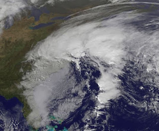
Much of the east coast from New Hampshire to Georgia have felt the effects of Ida's remnants with NJ, DE, VA and NC taking the brunt of the storm.

At one point yesterday, the minimum central pressure of the nor'easter was lower 15 miles east of Cape Hatteras than it was at landfall in Alabama as a tropical storm. Ida made landfall with a pressure of 999mb, while a measurement of 992mb was recorded off the Carolina coast Thursday, Nov 11, 2009. It was stronger along the east coast versus the Gulf coast!

Although winds have been strong, it is more the duration of those winds and their affect on the ocean that has caused the most damage. Nags Head, NC has sustained quite a bit of oceanfront damage to homes and parts of HWY 12.

Winds have been averaging in the 30's and 40's with wind gusts in the 50's and 60's with reports of hurricane force wind gusts (75 mph) in the tidewater area of Virgina. This area has experienced stronger storms before, but the damage is worse because the storm has been sitting here for 3 days now. That duration has allowed the storm to erode much of the protective dune system and the beach itself. As a result, as each successive high tide moves in, there is less in the way of natural protection for the property along the immediate coast. It's not like a hurricane or tropical storm that barrels through lasting a day or so. The longer this sits there, the easier it is for the sea to cause more damage.

Fortunately, the storm is now beginning to move back offshore toward the ESE and is loosing it's strength as it does so. This storm will go down in the history books as one of the worst as far as damage goes.

For a look at some raw video of damage in Nags Head, NC click here (courtesy of http://www.hurricanetrack.com/)

Friday, August 28, 2009

Danny Shmanny!


Here's a quickie...

Just to give you an idea of the lack of convection associated with Danny's center right now, take a look at this satellite image and compare the thunderstorms in Tampa today to the lack there of surrounding the center of Danny. Sure there are 40mph sustained winds NE of the tropical storm's center, but that is about it. We had heavier rain and lightning here today than the area under Danny's center.

A more important thing to notice is the convection firing along the southeast Georgia and South Carolina coast and into their coastal waters. It is THIS setup that will allow Danny to strengthen and spread a little wind and rain as it moves up the east coast. That is a "baroclinic" development and not a typical "tropical cycle" development. Those storms near the coast are developing well outside of the storms center and are a result of the wind flow, an existing trough and airmass collisions that are taking place on Danny's western side. For Danny to strengthen tropically, you would see thunderstorms develop over the center.
Just think "nor'easter" as this ruins one of your days at the beach this weekend...if you consider that ruining it!

Thursday, August 20, 2009

Surf's Up!!! Thanks, Bill.

Hurricane Bill is churning in the Atlantic and and finally brightening up what has been a dismal summer for surf along the east coast.

As of 5 p.m. Thursday, August 20, 2009, the storm is a category 3 hurricane with 125 mph winds near the center. It is drifting toward the NW at 18 mph and the forecast track takes it to the north and just east of Boston - who will get one heck of a nor'easter out of this by Sunday!

That track is great for surfers as it remains offshore, but pumps large swells to the coast. The hurricane force winds extend outward 125 miles while tropical storm force winds extend outward 260 miles. This is a big storm and because of it's large diameter of wind a large swell will be generated. Swell is basically created by "x amount of wind" blowing over "x amount of sea surface" for an "x amount of time". Increase any of those parameters, and you generally get bigger swell. The only problem is how your local beach break handles the large swells. Usually, the waves ends up "closing out" (entire wave breaking at one time - not as fun to surf) in most places, but there are a few...that will remain unlisted here, that will hold a larger swell. Hopefully they won't be too crowded.

High surf advisories go into effect along the NC coast Friday afternoon and will remain in effect through Sunday. Surf south of Cape lookout will approach the 7-10' range while the northern outer banks will be looking at 10-14' waves with a few higher sets. That's nearly triple overhead!

Here is a look at the current sea wave map for the North Atlantic. You can see Bill in the lower right. The lighter blues are 2-4' waves that have been lapping on the shores the past 2 days and the arrows are the swell direction. You can see they are headed right for the U.S. east coast.


The swell will continue to build through Saturday for the southeast coast, then slowly diminish into next work week - or the firs couple of "sick" days for surfer. I don't expect much to be left over along the southeast coast after Monday.

The northeast U.S. will be another story. Swell initially arriving from the southeast will be enhanced by a strong easterly component as the storm moves just east of Boston. This will create quite a mess as far as waves go, with quite a bit of swell direction change in a short amount of time. The largest and best swell to surf, will be the long trough swell Bill is now generating.

Take a look at this forecast for Sunday. A strong southeast swell will continue to provide much fun, but the winds from the storm will be affecting the New England coast - and it's surf.

The northeast U.S. should keep an eye on this storm as the track has actually shifted a little west the past couple of days. Either way, the surf will be up finally. Now, can this former NC surfer get some surf in the Gulf?

Thursday, July 16, 2009

Dusty Tropics

Once in a while you will hear us mention Saharan dust storms and how they can affect tropical cyclone development in the Atlantic Ocean. Well for the past few days, I have been tracking a large area of that dust that is crossing the tropical waters of the Atlantic. Typically, a plume this large can severely inhibit the formation of tropical storms so tracking these can give forecasters a clue as to what might happen - or not happen.

The dust becomes airborne when large storms over the Sahara desert in Africa kick up the dust. That dust can inhibit tropical development as it tends to dry out the atmosphere. Studies have revealed that the anvil tops of thunderstorms can be reduced in size due to the presence of dust, but at the same time updrafts can be enhanced causing heavier rain and gustier winds within thunderstorms. This dust can also cause large algae blooms and can cool the surface water temperature and cool the atmosphere.
This latest image shows a large area of dust moving across the Caribbean from east to west centered from eastern Cuba to just east of Puerto Rico. (the red and yellow areas) The dust clouds are easiest to see using enhanced satellite techniques like the one used for this image, but sometimes the dust is so thick that it can be seen on "tru color" imagery which closely resembles visible pictures.

Not only can the dust affect development of thunderstorms and tropical systems, but it can be a nuisance to us as well. South Floridians especially are familiar with the dust as occasionally large areas drift over the southern part of the peninsula and deposit some of the larger particles. I have been in parts of the Caribbean like Barbados, where the dust can be heavy at times and cause air quality concerns. Looking at the latest image, it appears that the car washing business might increase this weekend and next week in Miami!

To learn more about Saharan dust plumes, check out this article from NASA. http://tiny.cc/GpOaN