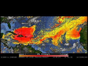
The dust becomes airborne when large storms over the Sahara desert in Africa kick up the dust. That dust can inhibit tropical development as it tends to dry out the atmosphere. Studies have revealed that the anvil tops of thunderstorms can be reduced in size due to the presence of dust, but at the same time updrafts can be enhanced causing heavier rain and gustier winds within thunderstorms. This dust can also cause large algae blooms and can cool the surface water temperature and cool the atmosphere.
 This latest image shows a large area of dust moving across the Caribbean from east to west centered from eastern Cuba to just east of Puerto Rico. (the red and yellow areas) The dust clouds are easiest to see using enhanced satellite techniques like the one used for this image, but sometimes the dust is so thick that it can be seen on "tru color" imagery which closely resembles visible pictures.
Not only can the dust affect development of thunderstorms and tropical systems, but it can be a nuisance to us as well. South Floridians especially are familiar with the dust as occasionally large areas drift over the southern part of the peninsula and deposit some of the larger particles. I have been in parts of the Caribbean like Barbados, where the dust can be heavy at times and cause air quality concerns. Looking at the latest image, it appears that the car washing business might increase this weekend and next week in Miami!
To learn more about Saharan dust plumes, check out this article from NASA. http://tiny.cc/GpOaN
